Monaco : A Laboratory for Urban Planning
Limited by its tiny amount of land, Monaco has had to constantly innovate to extend the limits of its territory.
‘Ten times the size of the Louvre Museum, three times the size of the National Mall in Washington DC, a third of an average Paris arrondissement, or just a quarter of the gardens of the Château de Versailles...' That's what the Principality of Monaco represents, as legal expert Delphine Lanzara* aptly sums up. The second smallest country in the world after the Vatican, the Principality is also the most densely populated. And its 2 km² surface area means that this micro-State has to meet unique urban planning challenges, combining infrastructure needs comparable to those of a medium-sized metropolis and an average square metre of land costing more than 50,000 euros....
Monte-Carlo: constant renewal
The Principality is often associated with Monte Carlo, especially its casino and luxury hotels. Originally, the Spélugues plateau - named, in Monegasque language, after the caves it sheltered - was a wild, arid land with olive and carob trees, a handful of fruit trees and a few vines. In 1866, Charles III gave his name to a new town built around the casino and the Hôtel de Paris. Hotels, restaurants, cafés and apartment blocks all sprang up, and the church of Saint-Charles was opened in 1883. A red and gold Italian-style theatre in the style of the Second Empire, the Salle Garnier is a miniature replica of the Paris Opéra House, which the eponymous French architect had just built. The iron beams he used to form the framework, were designed by Gustave Eiffel, father of the famous Tower and the interior structure of the Statue of Liberty. At the time Monaco symbolised renewal and modernity. Just as today, One Monte-Carlo and the new casino square symbolise the same, as does as the project for high-rise buildings that would stand on fifteen-metre stilts, conceived by the Department of Forward Planning as part of a review of the Spélugues plateau...Aware of the geographical limits of available space, the Principality has implemented several strategies over the years to increase the density of its territory. Vertical urbanisation, which began in the 1960s, radically transformed Monaco's landscape. The first 20- to 36-storey skyscrapers gave Monaco an appearance similar to that of major cities, with high-rise buildings such as the famous Tour Odéon, which rises to 170 metres and boasts one of the most expensive flats in the world. At the same time, Monaco has developed underground city planning, with the construction of tunnels, car parks and buried logistics infrastructures. This approach has freed up space above ground for gardens and green spaces, which now account for almost 20% of the territory. The underbelly of the Principality also houses key infrastructures including the mail sorting centre, technical facilities and event venues such as the Grimaldi Forum.
Gaining land from the sea
Faced with the impossibility of extending its country’s frontiers, Monaco found an innovative solution: conquering the sea. Since the 1960s, the Principality has undertaken a number of land reclamation projects, notably in the Fontvieille and Larvotto districts. In all, almost 60 hectares have been reclaimed from the Mediterranean, representing around 20% of Monaco's total land area. These extensions provide space for new housing, infrastructure and leisure facilities. The latest example of this ‘peaceful conquest’ is Mareterra with 6 additional hectares located between Larvotto and Spélugues.
Rebuilding the city on the city
Another key strategy is to rebuild the city on top of itself. Monaco is demolishing existing buildings to replace them with more modern, functional structures. This process of urban renewal can be seen in landmark projects such as the reconstruction of the Princess Grace Hospital and the One Monte-Carlo complex. This method enables the Principality to meet growing demand while optimising limited space. Due to the scarcity of available land, the Principality has acquired land in neighbouring French communes to build housing for civil servants, sports facilities and storage areas, although the land remains legally under French or Italian sovereignty. An example is the Monte-Carlo Country Club, home of the famous Rolex Masters tennis tournament, located in Roquebrune.
Finally, the latest trend..... A plan to renaturalise the city is included in the National Biodiversity Strategy for 2030. ‘As Monaco is the most densely populated coastal city in the world, climate change will exert additional pressure on local populations and biodiversity. It is therefore necessary to prepare a resilient city for tomorrow by integrating the services provided by nature’, explains the Department of the Environment. As part of this plan, a target of rewilding at least 20% of road surfaces has been set for 2030, ‘i.e. a gain of more than 13 hectares areas favourable to biodiversity’. An additional 2,400 trees are to be planted between now and 2030, while ‘the development of green infrastructure on buildings, such as intensive roofs and modular green walls, will be encouraged to “make the city greener”.
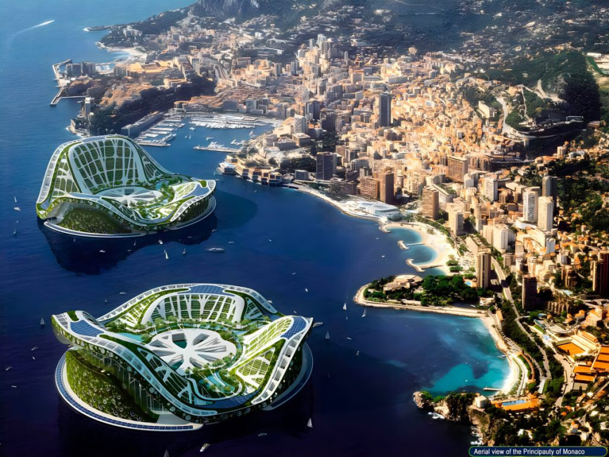
In the future, Monaco will continually need to innovate. Some architects, such as Édouard Albert, famous for the University of Jussieu, have envisaged artificial islands off the coast of Monaco. The idea of floating cities has recently re-emerged with Vincent Callebaud's utopian ‘Lilypad’. The Franco-Belgian architect conceived this “Eco polis”, capable of housing up to 50,000 people as a sustainable response to both the rise in climate refugees and the over-urbanisation of coastal areas. And what if these were Monaco's future pieds-à-mer?